


pissieu

DaVinci
User
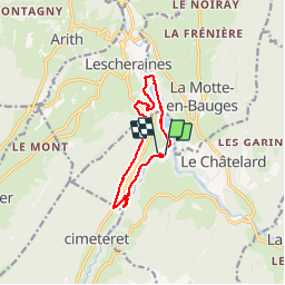

Length
10.1 km

Max alt
795 m

Uphill gradient
274 m
Km-Effort
13.8 km

Min alt
598 m

Downhill gradient
271 m
Boucle
Yes
Creation date :
2019-07-29 11:51:34.512
Updated on :
2019-07-29 14:51:08.381
2h58
Difficulty : Easy

FREE GPS app for hiking
 SityTrail
IGN / Geographical institutes
SityTrail Plus
The world is yours!
About
Trail Nordic walking of 10.1 km to be discovered at Auvergne-Rhône-Alpes, Savoy, Le Châtelard. This trail is proposed by DaVinci.
Positioning
Country:
France
Region :
Auvergne-Rhône-Alpes
Department/Province :
Savoy
Municipality :
Le Châtelard
Location:
Unknown
Start:(Dec)
Start:(UTM)
275534 ; 5063476 (32T) N.
Comments